Figure 1: Macquarie Arc located in the New South Wales, Australia.
Emmerson's strategy is focused on generating world class, copper-gold projects in stable jurisdictions.
Emmerson identified the Macquarie Arc in NSW as a world class, metal endowed geological belt which for a variety of reasons, is well under-represented in terms of its expected metal endowment. The impressive known endowment consists of >80Mozs gold and >13Mt copper with these resources heavily weighted to areas of outcrop or limited cover.
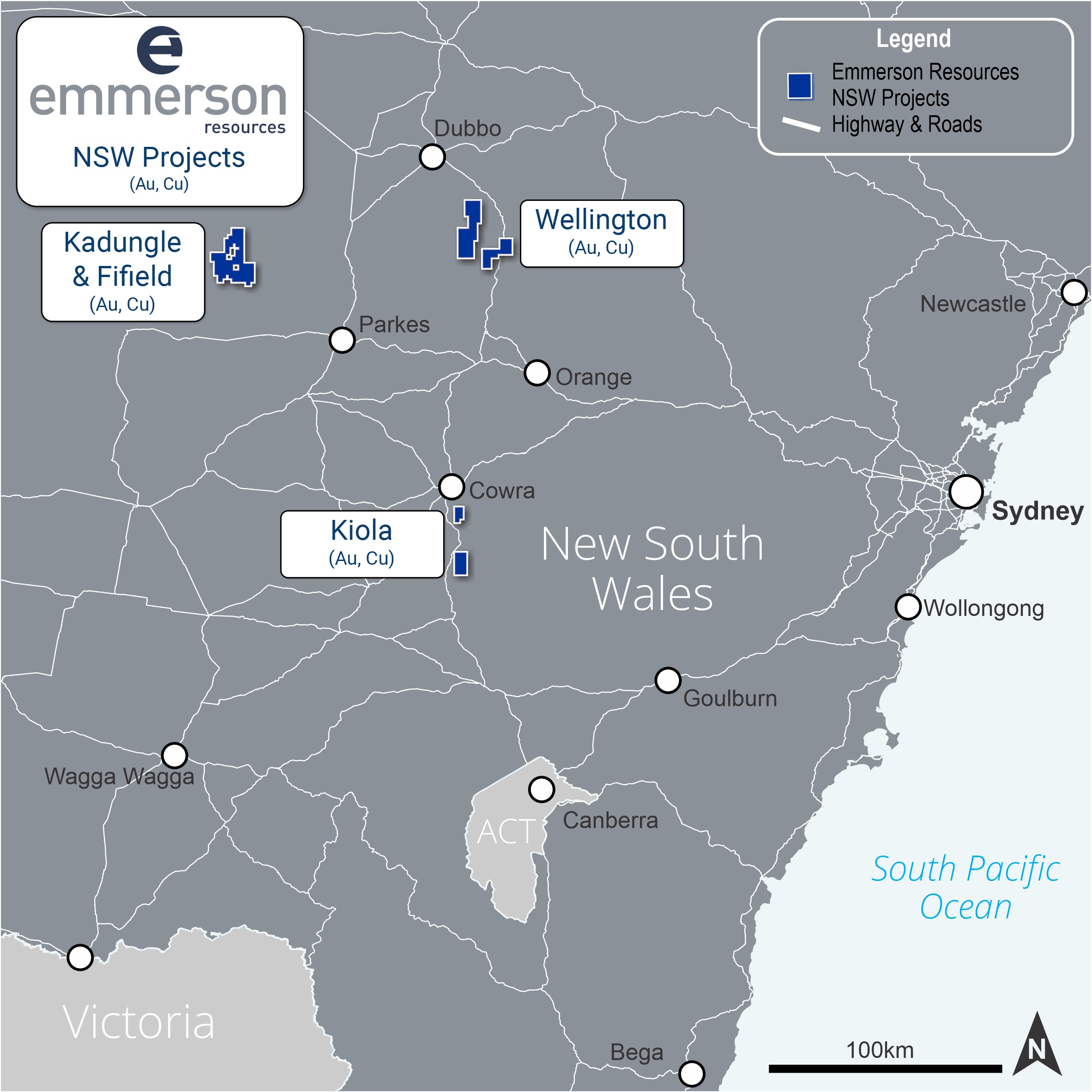
Emmerson's counter-cyclic entry into NSW in 2016 coincided with the downturn in the mineral industry, affording an opportunity to apply for large ground positions over highly prospective portions of the poorly exposed Macquarie Arc. Emmerson's five exploration projects (Figure 2) contain many attributes of the known deposits within the Macquarie Arc but remain under explored due to historical impediments, including overlying cover (farmlands and younger rocks).
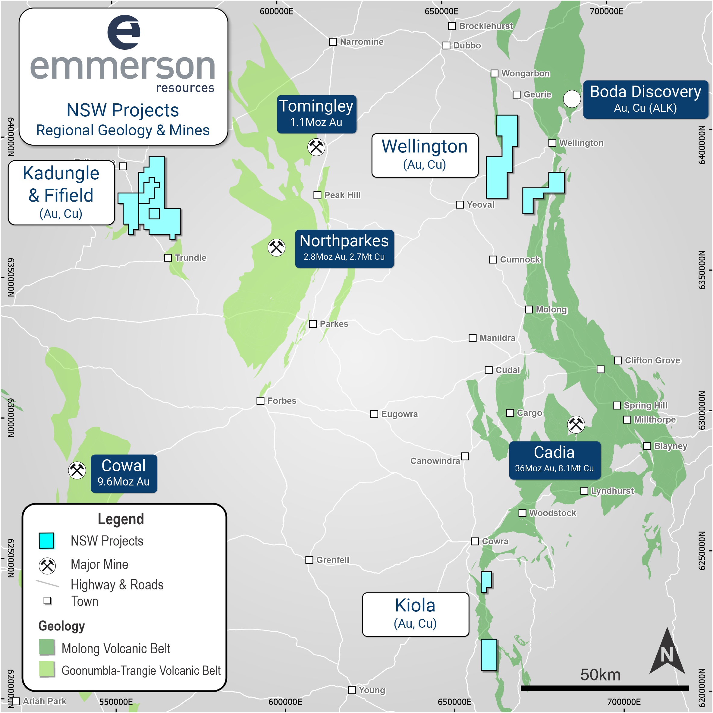
Figure 2: Location of Emmerson’s NSW Projects (held by Lachlan Resources – a 100% owned subsidiary of Emmerson)
Geological Province
The Macquarie Arc is part of the eastern sub-province of the Lachlan Orogen (Figure 2) and is the host to numerous porphyry Au–Cu deposits. It consists mainly of subduction-related Ordovician intermediate and mafic volcanic, volcaniclastic and associated intrusive rocks and was accreted to Gondwana in the Early Silurian and underwent rifting and burial in the Middle to Late Silurian.
It consists of four structural belts, namely, the western (Junee-Narromine), the central (Molong), the eastern (Rockley-Gulgong) Belt, and southern (Kiandra) volcanic belts. The evolution of these belts has been widely debated, but the most generally accepted scenario is that these were formed by rifting and dismemberment of a single arc, which developed along the boundary between the Australian and proto-Pacific plates during the Ordovician and was subsequently dismembered during the Silurian.
An entirely intra-oceanic setting is postulated for the Macquarie Arc (Crawford et al., 2007), with four phases of arc-type magmatism, the earliest in the Early Ordovician, and culminating in the Late Ordovician to Early Silurian. Geochemical and paleontological data indicate that the Macquarie Arc evolved episodically over ~50 million years (Crawford et al., 2007). The four phases of volcanism in the Macquarie Arc relate to distinct groups of porphyritic intrusions that vary from monzodiorite-diorite through monzonite-granodiorite compositions and correspond with porphyry copper-gold and epithermal gold-silver mineralisation.
Kadungle Project
Commodity
- Copper, Gold
Deposit Style
- Porphyry and Epithermal
Tenement Holding
- EL8999 – 43.3 km²
Ownership Status/Partners
- Emmerson Resources, Longreach Mineral Exploration, Aurelia Metals
Exploration Phase
- Target Testing & Target Definition
Historical drilling by Aurelia Metals (ASX:AMI) indicated potential for both shallow gold-silver and deeper, copper-gold mineralisation.
The Kadungle project is situated adjacent to Emmerson’s Fifield project and consolidates a large package of ground within the prospective Lachlan Transfer Zone (LTZ) (Figure 3).EL8464 Fifield is located just south of Tullamore (Fig. 2) and approximately 50 NW of Northparkes Cu-Au mine. The terrain over the Ordovician arc is flat to gently undulation. EL8464 covers an area of 66.4 km².
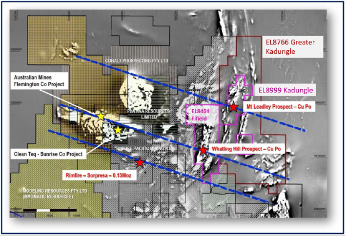
Figure 3: Kadungle, Fifield, and Greater Kadungle tenements located within the highly prospective Lachlan Transfer Zone (blue dashed lines). Note the background image is a grey scale image of the aeromagnetics
Geological Setting
The oldest rocks outcropping in the vicinity of Kadungle, and Fifield are the Ordovician to Early Silurian Girilambone Group. These rocks are deformed basement consisting of quartzite, phyllite and schist. The Girilambone Group outcrops in the extreme west of the Exploration Lease (EL) 8999 and EL8766, where several strong magnetic, platinum-bearing, ultramafic complexes intrude (Figure 4).
East of Tullamore and the Gobondery Granite, the basement is less deformed, separated by the north-south Fifield-Steetone fault system. Further to the east, the basement is comprised of Early Ordovician Nelungaloo Volcanics and the overlying, more widespread, Late Ordovician trachyandesitic Goonumbla Volcanics.
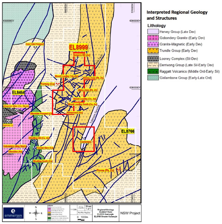
Figure 4: Regional Geologic setting for the Kadungle Project (EL8999), Greater Kadungle (EL8766) and adjacent Fifield (EL8646) Project
The Ordovician Raggatt Volcanics outcrop on the eastern contact of the Gobondery Granite and inside EL8766. Age dating of two intrusive samples collected by Emmerson Resources (2017) confirm the Ordovician age of the Raggatt Volcanics, with dates ranging from Middle to Late Ordovician to Early Silurian (Zircon U-Pb – UTAS-CODES).
The tenements are situated on the Siluro-Devonian Tullamore Syncline, and rock types are predominantly Devonian age, Kadungle Volcanics. Recent age dating of intrusions in Kadungle yielded an age of Early Devonian. Unconformably overlying this sequence are Late Devonian, quartz rich sandstones of the Hervey Group. The Raggatt Volcanics form the basement to the project area and are interpreted as rifted equivalents to the Goonumbla Volcanics that host the Northparkes porphyry copper deposits.
Project Status
The Kadungle Volcanics host numerous prospects including Mount Leadley and Mount Leadley South (Au, Cu), Trig (Au-Cu), Kilmarnock (Au), Nulgara Hill (Au), Alpha Zone (Au-Pb-Zn) and the Kidney Zone (Pb-Zn) (Figure 5).
Historical drilling at the Mount Leadley prospect indicates potential for both shallow epithermal gold-silver and deeper, porphyry style copper-gold. The Mt Leadley and the Mount Leadley South prospects represents a circular (~2.5km diameter) zone of intense silica-sulfide alteration and demagnetization hosting numerous broad and anomalous copper-gold intersections. The Mount Leadley prospect is centered on a strongly mineralized diatreme breccia (Figure 5).
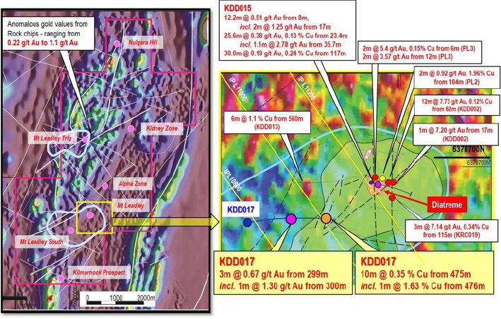
Figure 5: Plan of the Mt Leadley and Trig Prospects within the Kadungle Tenement. Background is the aeromagnetics with blue correlating to possible zones of magnetite destruction marking the hydrothermal alteration (ASX: 09 February 2018)
Completed work
- High resolution airborne magnetic and radiometric survey, 2D Induced Polarization (IP) and Gradient array IP (GAIP) survey
- Extensive field work – mapping and sampling
- Green-rock geochemistry and pyrite geochemistry studies (UTAS-CODES) to aid in vectoring and focus on the most prospective drill targets
- Age dating of key lithologies as part of the University of Tasmania CODES ARC Linkage project
- Whole-rock lithogeochemistry of selected rock units suggest potassium-rich rocks
- Various phases of drilling with the most recent at Mount Leadley and Mount Leadley South completed in January 2021.
Results
Drilling by Emmerson has indicated the presence of an early porphyry style alteration and mineralization, overprinted by a later epithermal event. The Mount Leadley prospects have seen hydrothermal fluids, with alteration dominated by quartz-albite-sericite-K-feldspar suggesting a large ~1.5 x 0.5 km mineralizing system with a NE-SW trend. Multiple intrusions have been intersected.
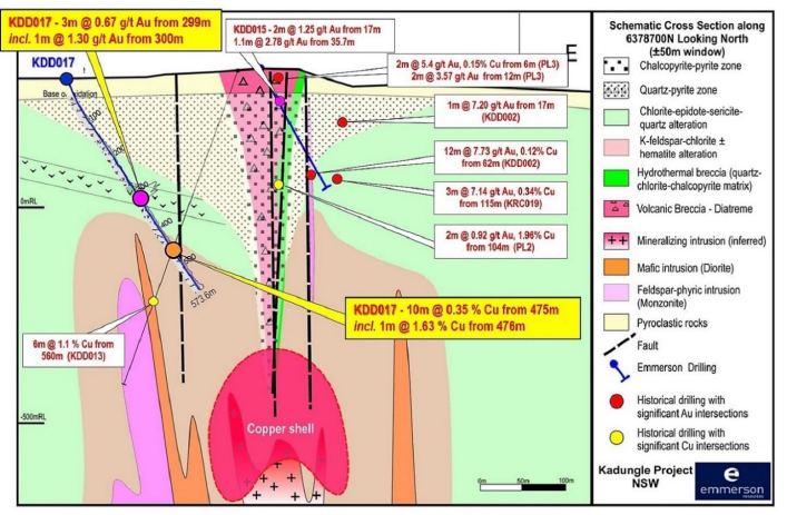
Figure 6: Schematic cross section of the interpreted Mt Leadley geology with recent drilling. Note the extensive chalcopyrite-pyrite and quartz-pyrite zones plus hydrothermal breccia at the margin of the volcanic breccia/diatreme. The red dots are historic intersections projected onto this section (ASX: 09 February 2018)
Planned work
- Assessmentof geology and geochemistry from recently completed deep drilling
- Structural analysis to better pinpoint potential higher grade gold mineralisation
Fifield Project
Tenement Holding
- EL8464 for a total of 66.3 km²
Commodity
- Copper, Gold
Deposit Style
- Porphyry, epithermal
Ownership Status/Partners
- Emmerson Resources, Duke Exploration
Exploration Phase
Target Testing & Target Definition
EL8464 Fifield is located approximately 50km NW of Northparkes Cu-Au mine, just south of Tullamore and adjacent to the Kadungle Project (Figure 8).
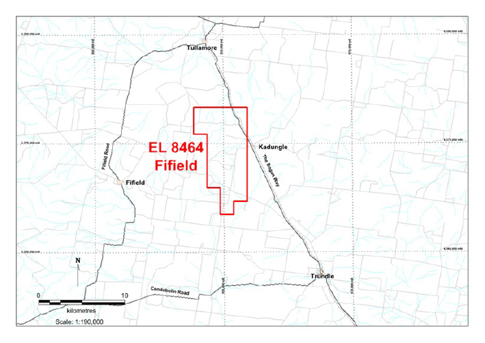
Figure 8: Location map of Fifield tenement EL8464
Geological Setting
The Fifield Project lies within an inlier of Ordovician arc interpreted to have been rifted from the North Parkes Igneous Complex. The main Ordovician arc is dominated by the Raggatt Volcanics consisting of andesitic to trachy-andesitic lavas and volcaniclastic rocks. The host Ordovician Raggatt Volcanics and related intrusives are truncated to the west by the Devonian Gobondery Granite, and to the east by the overlying Silurian conglomerates – providing a “window” of prospective, metal-fertile Ordovician rocks that likely extend undercover to the east where Emmerson has recently expanded its ground position to include the greater Kadungle project.
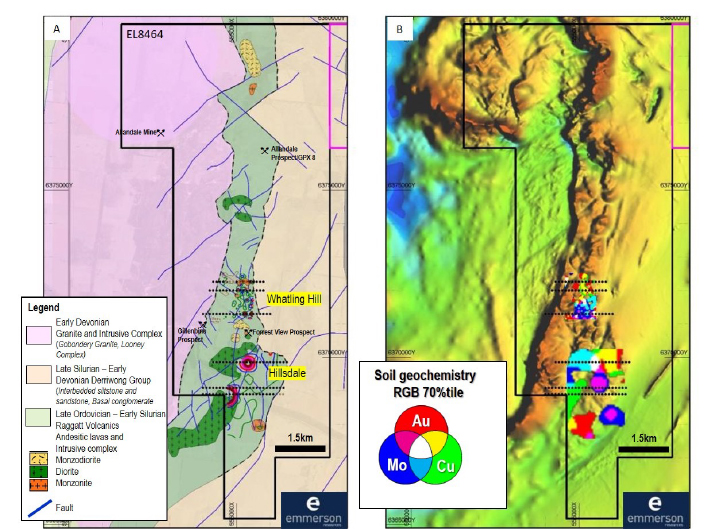
Figure 9: A) Local geology showing the lithology inside the tenement and the location of prospects. B) Total Magnetic Intensity, with ERM soil geochemistry
Project Status
The Fifield Project consists of various prospects including Whatling Hill, Hillsdale (Whatling South), Gillenbine, Kurrajong, Forrest View, Hillsdale, and Allandale.
Completed work
- High resolution airborne magnetic and radiometric survey and 2D Induced Polarization (IP) survey
- Extensive field work – mapping and sampling
- Green-rock geochemistry study (UTAS-CODES) suggest that that the project area is prospective for porphyry copper-gold
- Age dating of key lithologies as part of the University of Tasmania CODES ARC Linkage project (yielding a late Ordovician to early Silurian age) similar to world-class porphyry copper-gold deposits in the province (including the Cadia-Ridgeway deposit)
- Whole-rock lithogeochemistry of selected rock units plot in the high-K series (similar to Northparkes and Cadia-Ridgeway)
- Generation of a porphyry-epithermal geological model for Whatling Hill
- Completed two phases of drilling by Emmerson from 2018 - 2019 at Whatling Hill, Forrest View, and Hillsdale prospects.
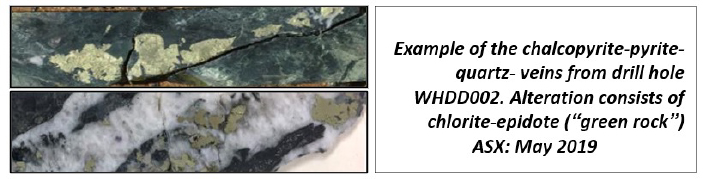
Figure 10: Whatling Hill Prospect Diamond Drilling – mineralized zone – WHDD002
Results
-
Field-based exploration has been complemented by cutting-edge science, whereby analysis of the alteration suggests that Whatling Hill is within the geochemical footprint of a porphyry system
- Age dating has demonstrated that the targets are consistent in age with the mineralised intrusions at the world-class Northparkes and Cadia-Ridgeway copper-gold deposits
- First pass drilling at Whatling Hill successfully established the presence of porphyry copper style mineralisation. The program has been effective in providing an insight into the underlying geology in an area that is covered and has seen little previous exploration
- Deep drilling at Whatling Hill was only partially completed due to encountering drilling difficulties resulting in early termination. Although well above the target zone, several intervals of visible sulphides (pyrite and chalcopyrite) were encountered. These were associated with epidote, chlorite and sparse garnet, magnetite and actinolite alteration
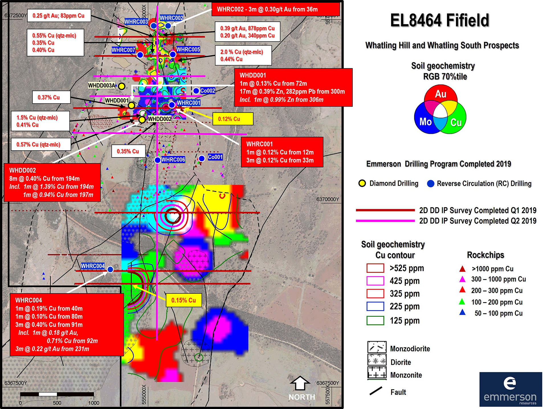
Figure 11: Location and assay results from drilling (red call out boxes) at the Whatling Hill Project. Background is the previously announced geochemistry, the IP geophysical survey (red lines) and rock-chip assays (red font), with peak assay results from the regolith (yellow call out boxes) (ASX: 21 May 2019)
Planned work
- Continue mapping and sampling of other targets north and south of Whatling Hill
- Additional soil sampling of other undercover targets inside the tenement
- Review and update geological and conceptual models from recent drilling results
Wellington Project
Commodity
- Copper, Gold
Deposit Style
- Porphyry, epithermal
Tenement Holding
-
EL8463 for a total of 254.3 km²
Ownership Status/Partners
- Emmerson Resources, Duke Exploration
Exploration Phase
- Target Definition
Wellington is located in the Molong Volcanic Belt within Ordovician volcanic and intrusive rocks of the Macquarie Arc that are host to the majority of the significant mineral deposits in the region, e.g. the giant Cadia-Ridgeway district. The recent Boda gold-copper porphyry discovery by Alkane Resources Ltd has highlighted the value of Emmerson's tenure position in the northern Molong Belt, in what is emerging as a globally significant gold-copper porphyry hotspot. (Figure 12).
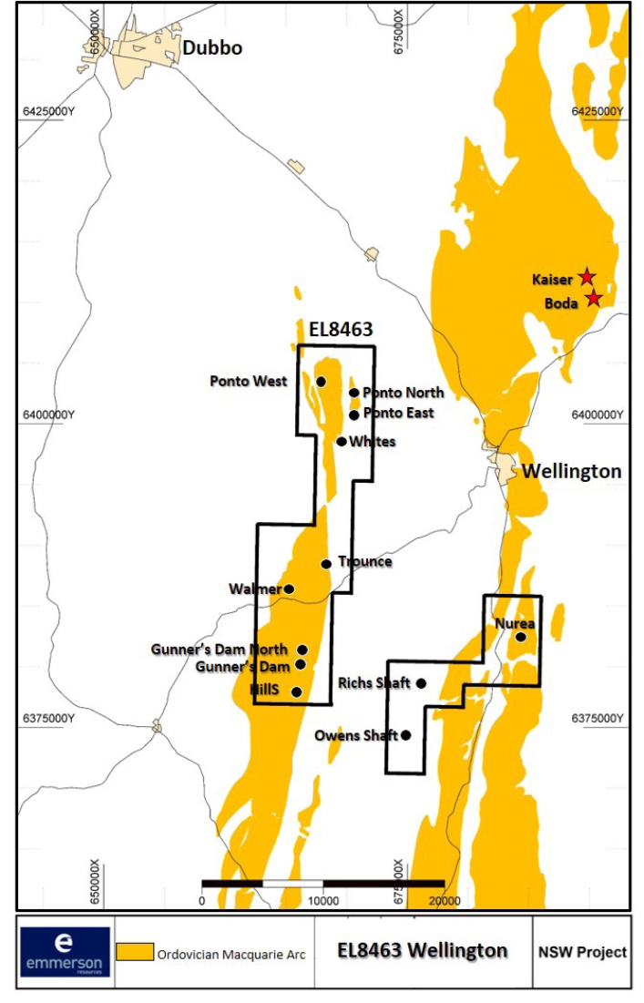
Figure 12: Location of the Wellington Project (EL8463)
Geological Setting
The Wellington Project is dominated by attenuated, folded, and faulted remnants of Ordovician volcanic arc rocks surrounded by Silurian to Devonian sedimentary, volcanic and volcaniclastic rocks of the Cowra trough. These are partially covered by Devonian basinal sediments and intruded by granitoid batholiths of the Yeoval Suite (Figure 13).
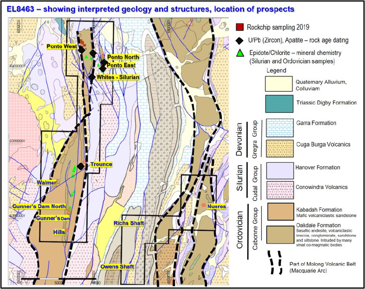
Figure 13: Map showing the geology of the Wellington Project (EL8463) and location of prospects
The Oakdale Formation of the Cabonne Group, which forms part of the Molong Volcanic Belt consists of interbedded and andesitic to latitic lavas, tuff, breccia, volcaniclastic conglomerate, sandstone and siltstone, minor limestone, limestone conglomerate and breccia (Pogson et. al, 1998). The Ordovician Oakdale Formation outcrops out as NS-trending bodies through the central and eastern section of EL8463 and is host to numerous localised gold and copper occurrences in the area.
Project Status
The Wellington Project consist of prospects such as Ponto, Walmer, Trounce, Gunners Dam, Neurea, Whites, Rich’s Shaft and Owen’s Shaft.
Completed work
- High resolution airborne magnetic and radiometric survey
- Extensive field work – mapping and sampling at Ponto Corridor
- Green-rock geochemistry study (UTAS-CODES) within the Ponto Corridor suggest that that the project area is prospective for porphyry copper-gold
- Age dating of key lithologies as part of the University of Tasmania CODES ARC Linkage project (yielding a Late Cambrian to Late Ordovician age)
- Whole-rock lithogeochemistry of selected rock units plot in the high-K series (similar to Northparkes and Cadia-Ridgeway)
Results
The Wellington Project is in its early exploration stage. Results from mapping, rock-chip sampling, and soil sampling analysed via the ARC Linkage Project (headed by UTAS-CODES) has highlighted the potential for porphyry copper-gold mineralization associated with Ordovician intrusive centers.
Planned work
-
Ponto Corridor:
- Assess what ground geophysical survey is appropriate to better define the anomalies at depth to aid in focusing drilling
- Other targets inside the tenement (Walmer-Trounce- Gunner’s Dam Corridor, Neurea, Owens Shaft) will be further investigated with detailed mapping, sampling and possibly soil sampling or shallow drilling to further define targets
Kiola Project
Commodity
- Copper, Gold
Deposit Style
- Vein-hosted Au, Skarn, Porphyry
Tenement Holding
-
EL8590 for a total of 71.0 km²
Ownership Status/Partners
- Emmerson Resources, Duke Exploration
Exploration Phase
- Target Testing
The Kiola Project (EL8590) is located between the townships of Cowra and Boorowa, in central NSW (Figure 14). The Kiola prospect occupies a portion of the Ordovician Molong Volcanic Belt, which also hosts the world class Cadia-Ridgeway Cu-Au porphyry deposits situated 50km to the North (Figure 15).
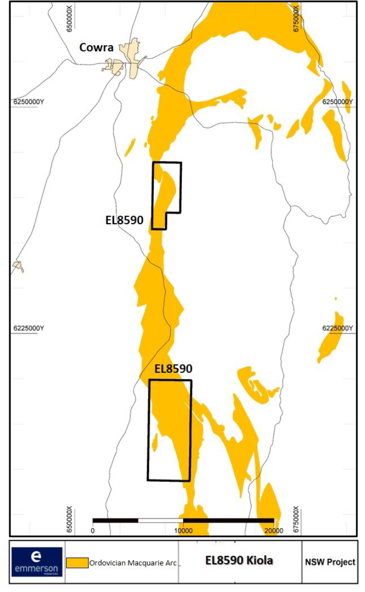
Figure 14: Location of the Kiola Project (EL8590)
Geological Setting
Kiola is situated east of the Benambran unconformity and within 5km-10km of the Lyndhurst-Neville Fault (locally termed the Frogmore Fault zone). The dominant host rocks belong to the late Ordovician Kenyu Formation and comprise of volcaniclastic sediments, andesites/basalts and lesser felsic pyroclastics (low- medium K) with minor black shale and limestone. The Kenyu Fm is bounded to the west by the Silurian Hawkins volcanics (rhyolite, rhyodacite and ignimbrites with volcaniclastic sediments and minor limestone) of the Cowra Trough. The tenement is bounded to the east by granites of the Silurian Hovells Suite (Wyangala and Licking Gully Granites), which in turn are intruded by the Devonian Boggy Plains (Wyoming) Granite and Cainozoic basalt (Figure 15).
The Frogmore Fault Zone, a key controlling structure, has a long history of intense faulting, folding, and thrusting, having formed during the Benambran orogeny, and then reactivated during the Tabberabberan and Kanimblan deformation events.
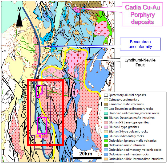
Figure 15: Map showing generalized geology of the Kiola Project (EL8590)
Project Status
Kiola is one of Emmerson’s higher ranked, early-stage gold-copper projects in the NSW portfolio and is centred on the 15km2 Kiola Geochemical Zone (KGZ). It encompasses favourable Ordovician age rocks that display anomalously high gold and copper geochemistry plus numerous historic workings. Recent work has confirmed that the KGZ contains many of the attributes of world class porphyry gold-copper mineralization. The KGZ hosts several prospects including: the Nasdaq skarn, Stewart and Party, Dolly’s North, South Pole, Kiola, Right Hand Creek mine, Little Point and Yards areas.
Completed work
- Extensive field work – mapping and sampling
- Reprocessing of historical geophysics and structural interpretation of the data
- Green-rock geochemistry study (UTAS-CODES) suggest that that the project area is prospective for porphyry copper-gold
- Age dating of outcropping Monzodiorite and inferred to be a part of the Kenyu Formation yielded a Middle to Late Ordovician age (U/Pb UTAS – CODES)
- Whole-rock lithogeochemistry of selected rock units plot in the high-K series similar to Northparkes and Cadia-Ridgeway
- Completed ground geophysics – 2D and 3D M.I.M. Distributed Acquisition System (MIMDAS) Induced Polarisation (IP), Resistivity and Magnetotelluric (MT) surveys
Results
- High grade copper and gold rock chip samples of up to 19.6% copper and 0.36g/t gold (ASX: 3 June 2018) are now supported by results from trace element proximity indicators (within the alteration minerals of epidote and chlorite) and whole-rock geochemistry of rock units from the Kenyu formation plot in the shoshonite series, similar to Cadia-Ridgeway
- First pass diamond drilling within the prospective 15km2 Kiola Geochemical Zone (KGZ) has confirmed potential for further gold and base metals at the Nasdaq skarn and the possibility of deeper copper-gold associated with an underlying porphyry system
- Large MIMDAS geophysical survey completed at the Kiola project in NSW – identified compelling gold-copper targets to assist 2021 exploration targeting
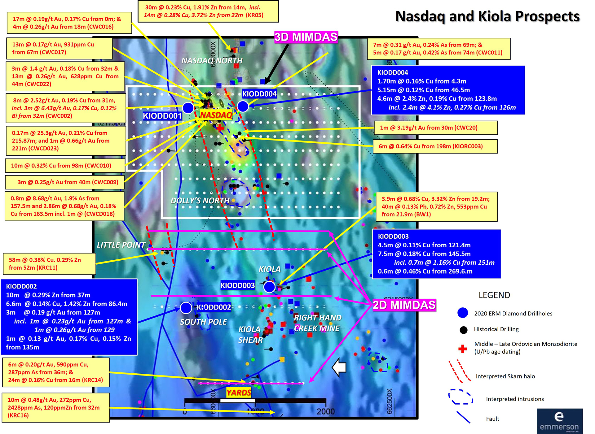
Figure 16: Plan view of the Kiola Geochemical Zone (KGZ) showing historic and recent drill results at the Nasdaq skarn, and the southern South Pole, Kiola, Right Hand Creek Mine. Also showing the completed MIMDAS 3D survey outline at Nasdaq prospect and the proposed MIMDAS 2D Survey at Little Point, Kiola and Yards prospect (ASX: 27 August 2020)
Commentary from Emmerson Managing Director Rob Bills - 3D Kiola GPX MIMDAS Geophysical Model and inversions stretching over 5km from the mineralised Nasdaq skarn in the north to the Yards prospect located under cover in the south. Proposed Emmerson drill hole traces (KProp1 to KProp4). Noting the red zones indicate a mantle of chargeable and conductive bodies centered on the Dolly’s North magnetic, monzodiorite body (brown)
Planned work
- Further geochemistry and analysis to refine the understanding of intrusions and identify fertile porphyries
- Review of the MIMDAS geophysics to establish drill targets